Building the Salem Witchcraft GIS
Historical Geographic Source Materials for the Salem GIS
A: W.P. Upham's "Map of Salem Village, 1692" (1867)
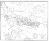
Our primary source of geographic information for Salem in 1692 comes from Charles W. Upham's Salem Witchcraft, With an Account of Salem Village and a History of Opinions on Witchcraft and Kindred Spirits. This first major study of the Salem trails was published in 1867, and included a map that purported to represent the locations of major landmarks, farms, land grants, physical features, and the dwellings of prominent and important residents in Salem during 1692.
 |
View Small Sized Image (640 x456) |
| View Medium Sized Image (1534 x 1092) |
|
|
View Larger Sized Image |
|
|
|
|
B: Sidney Perley & William Freeman's map of "Part of Salem in 1700" (1933)
This map shows details about Salem Town, which is represented at a very small scale, and with few details, on Upham's map. Pereley & Freeman's map is drawn at a much larger scale than Upham's, enabling him to show homesteads and dwellings as plots of land, rather than simply points. Pereley's researches were used by William W.K. Freeman to draw the map, which was published in 1933 by James Duncan Phillips.
 |
View Small Sized Image (600 x 505) |
| View Medium Sized Image (2700 x 2271) |
|
|
View Larger Sized Image |
|
|
|
|
C: Andover Historical Society "Plan of Andover. . . 1692" (1992)
Andover is located to the northwest of Salem and is not shown on either of the two maps shown above. As the witchcraft drama wore on, accusations were eventually made against residents of nearby towns, including Andover. The "Plan of Andover in the Province of Massachusetts Bay, Essex County, 1692" was drawn by James S. Batchelder, based on research by Forbes Rockwell and Carl R. Smith, and by Gratia Mahony.
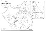 |
View Small Sized Image (600 x 400) |
| View Medium Sized Image (1500 x 1000) |
|
|
View Larger Sized Image |
© Copyright 1999 The Rector and Visitors
of the University of Virginia
ArcInfo is a trademark of the ESRI
Corporation; Access is a trademark of Microsoft Corporation