Building the Salem Witchcraft GIS
Digitizing the Upham Map
K. Registration of the Upham Map
We performed several different registrations of Upham's map, in order to examine the effect of using certain control points and leaving out others. Successive attempts allowed us to determine which points provided the best match and fit of the map to the real world data we had to work with.
 |
|
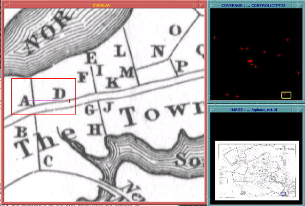
| ABOVE: the navigational windows in ArcInfo that enable overlay of control points with the map image, enabling the user to create links between the two. The two smaller windows at right allow the GIS technician to control the areas that will be overlaid. The area at left is where the links are drawn, by clicking the mouse first on the target point, and then on its corresponding control point. The area boxed in red is show in detail below | |
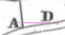 |
LEFT: point A on the map image is being linked to the control point (represented by the purple line) to the control point represented by the "+" sign. |
Ultimately we used only nine of the sixteen available control points to register the map. The remaining seven, we felt, represented large areas that we could not well match with a point, or represented points on Upham's map that appeared to be imprecise or inaccurate. The remaining nine points provide enough geographic spread to ensure accuracy.
| ID# | Mapsymbol | name |
|---|---|---|
| 95 | 95 | Rebecca Nurse House |
| 93 | 93 | Sarah Holten House |
| 68 | 68 | Bridget Bishop (Edward Bishop)House |
| 48 | 48 | Parsonage |
| 151 | 151 | Jonathan Corwin House |
| 185 | none | Will's Hill |
| 107 | 107 | John Hale House |
| 188 | none | Humphrey's Pond Island |
| 186 | none | Wenham Lake |
LAST
MODIFIED:
MAINTAINED BY: geostat@virginia.edu
© Copyright 1999 The Rector and Visitors of the University
of Virginia
ArcInfo is a trademark of the ESRI Corporation; Access is a trademark of Microsoft Corporation