Building the Salem Witchcraft GIS
Digitizing the Upham Map
L. Results of Registration: Error and Offset
The Effect of Map Scale and Generalization
Map scale and generalization have had a dramatic effect on the accuracy of this map registration. Upham drew his map at a scale of one inch to the mile (1:63360), which is a much smaller scale than the aerial photography with which we identified existing points (1:5000).
At such a scale, features are generalized, or drawn with less precision. Points and symbols Upham used to represent features introduce much chance of error. If we were to take the scale literally, a church which Upham drew as symbol 1/4 inch wide would be presumably be 1320 feet wide in reality. A point 1/8 inch wide representing a dwelling occupies 660 feet according to this scale.
Matching relatively large symbols to a precise geographic coordinate of latitude and longitude, representing a point infinitely small, can only produce significant offsets, and result in inaccuracy in the data.
Registration Offset
Offset describes the distance between a point on registered map, and the "true" location describe by the corresponding control point. In effect, each registered point affects the accuracy of all others: all registration links produce offset on other links, as the software attempts to reconcile the locational data it has been given. Each link pulls on the others, and affects their ultimate position in geographic space.
When more than three points are used to register an image, GIS software attempts to minimize the offset distance between the point on the image and geographic coordinate. Offset is a normal and inevitable process, but it should be minimized to the extent possible by eliminating weak control points. Our final results were deemed acceptable to us only after we determined we were using the best set of controls and that offset would decrease no further.
The following table shows the offset distance for the control points used:
| ID# | Mapsymbol | name | offset (meters) |
|---|---|---|---|
| 95 | 95 | Rebecca Nurse House | 83.232 |
| 93 | 93 | Sarah Holten House | 104.250 |
| 68 | 68 | Bridget Bishop (Edward Bishop)House | 50.387 |
| 48 | 48 | Parsonage | 128.849 |
| 151 | 151 | Jonathan Corwin House | 134.047 |
| 185 | none | Will's Hill | 221.724 |
| 107 | 107 | John Hale House | 141.052 |
| 188 | none | Humphrey's Pond Island | 105.784 |
| 186 | none | Wenham Lake | 101.787 |
Comparative Distance Measures
Upham's map appears to be most accurate in the east, less accurate in the west. The relative shape/distribution of the points on the map and the control points match fairly well: there are no dramatic surprises.
However, distances are off quite a bit in comparison between the Upham map and known control points. Wills Hill to Hathorne Hill, Hathorne Hill to 39, and Wills to 39 all present quite a bit of difference. It seems that the actual distance is much farther in those cases than Upham's map depicts.
| Wills Hill to 39 | |
| Registered image | 4642.14 meters |
| Control points | 5072.30 meters |
| Hathorne's Hill to 39 | |
| Registered image | 614.70 meters |
| Control points | 790.52 meters |
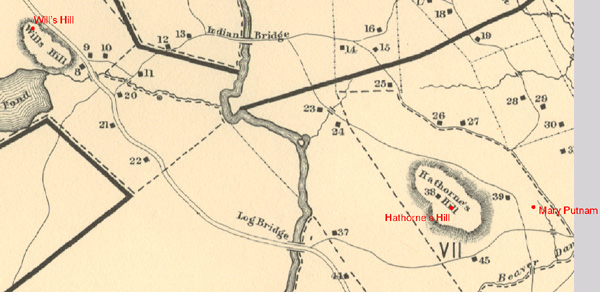 |
| ABOVE: Northwestern areas of the Upham Map, showing known control points (in red) and their corresponding points on the Upham map. Upham underestimated the distance between Will's Hill and point 39, as well as the distance between Hathorne's Hill and 39. |
Similar problems appear in the center of the map, where Upham has placed more distance between features than actually exist.
| S. Parris to Ingersoll ([P to +) | |
| Registered image | 200.65 meters |
| Control points | 139.90 meters |
| Ingersoll to 1702 Meeting House (+ to church) | |
| Registered image | 224.89 meters |
| Control points | 57.30 meters |
However, Upham is fairly accurate in some cases.
| Holton house to Nurse House (93 to 95) | |
| Registered image | 644.27 meters |
| Control points | 627.37 meters |
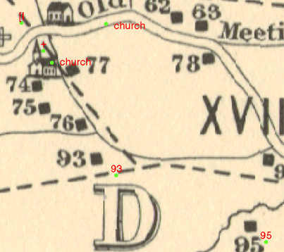 |
| ABOVE: Detail of central areas of Upham's map, showing control points (in green with red labels), and their corresponding features on Upham's map. While Upham was close in estimating the difference between 93 and 95, he was quite far off in drawing pinpointing Nathanial Ingersoll (+) and the 1702 Meetinghouse (the church to Ingersoll's southeast. Map scale and generalization of features play a role here, but that accounts for only part of the error. |
Average Pixel Resolution
Average pixel resolution of the registered Upham map is 4.691 meters/pixel. As a point of comparison, the aerial photography which we used to match control points is much more finely detailed: 1 meter/pixel.
© Copyright 1999 The Rector and Visitors
of the University of Virginia
ArcInfo is a trademark of the ESRI
Corporation; Access is a trademark of Microsoft Corporation